


Help
Community21 has selected some case study communities and projects to share across the network to inspire and inform others. Should we be featuring yours? If so get in touch.
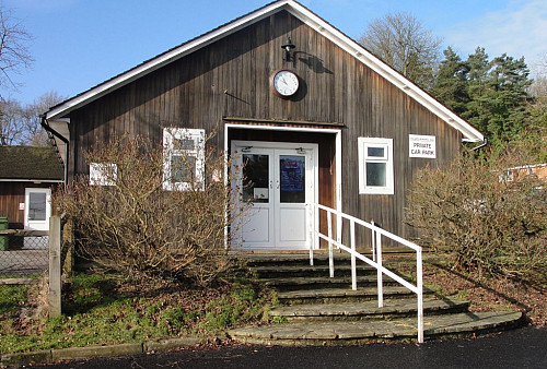
Woodmancote is a rural parish covering an area some 2090 acres but only about 200 dwellings and a population in the region of 500. Blackstone is the geographical heart with the boundaries being the B2116 to the north, and south of the A281 in the south. It borders Henfield to the west and Albourne to the east. St Peter’s Anglican church is situated on the A281 and is thought to date from the 13th Century, having been substantially rebuilt in 1868. In the churchyard there is a monument to two protestant martyrs, Thomas Harland and John Oswald, who were burnt at the stake in Lewes in 1556 in the Marian Persecutions. The church hall, which serves as the parish hall, is situated nearby and is where parish council meetings are held at 7.30pm on the second Tuesday of each month. Members of the public are always welcome to attend.
OCTOBER 2014.
A special inaugural meeting took place prior to the usual monthly Parish Council meeting in October. The meeting was well publicised on Parish notice boards and on the Parish website inviting any members of the Parish community to attend if they were able to offer their time and help by being part of the Neighbourhood Plan process. Its purpose was to establish a Steering Group for the (WNP) Woodmancote Neighbourhood Plan. Councillor David Austin had earlier agreed to take the role of chairman for the WNP with Jose Ochoa agreeing to be the RFO. The chairman outlined to all present what would be involved and asked for volunteers. A number of people put their names forward and the Steering Group was duly formed. The chairman pointed out that a second tier of committees would need to be formed called Focus Groups. These would report to the Steering Group and it was agreed that these Focus Groups would be created from the volunteers at a future meeting. The next WNP meeting was set for the 11th November.
CALL FOR SITES ends 2nd December 2014
For more details, click here