Hollingdean - Mapping sustainable citizenship across the City 2017

March 31st 2017 - Critique of the previous map

Content

  • There appeared to be several different levels of depth of research on the same map: some markers gave clear, relatively detailed information (illustrated by appropriate photographs), while others offered minimal information of dubious relevance to environmental citizenship (E.C.).

  • In some areas of the map great emphasis was placed on some aspects of environmental citizenship that our group felt should be placed on others (e.g. there were several markers for recycling bins, but little on recycling facilities).

Communication and Presentation

  • Our group found it hard to evaluate the efficacy/impact of each project (facility, group, etc) on the basis of so little information. We propose to add a scoring system (e.g. assigning stars), perhaps even one that takes into account multiple variables. Efficacy, for instance. Number of goals, or whether different goals cover different aspects of E.C. (such as food waste reduction and support for local producers).

  • Another possible addition may be quotes from people who work for/benefit from/ support each project/ initiative.

  • Finally, regarding clear presentation and ease of communication, our group recommends that the information sheets for each marker be formatted the same way (if at all possible). The addition of subheadings to break down the information in easily accessible and comparable sections should also be considered.

March 31st Blog post 1

Before venturing into the field, we decided to conduct a preliminary meeting in the library to get to know each and organise our strategies to work effectively as a group. We began by researching the activities going on within our ward and determined the places we planned to visit. We decided to divide the themes between the group, allocating one to each person to carry out further research and write up following our visit. The group predominantly gained information through organisations websites regarding visiting hours and possible events to attend. We then proceeded to set up a Facebook group in which we could communicate in addition to sharing photos and information throughout our study of Hollingdean.

7th April 2017 – Blog Post 2

The first field visit took place in the southernmost, most urbanized area of Hollingdean. We met at Saunders Park (an eco-park project) and we decided as a group to follow a route around Hollingdean that would take us past the agreed-upon examples of environmental citizenship, as well as allow for the discovery of new examples simply from wandering. The general idea was to find at least one example for each theme (food, waste, etc.), so each group member could participate in the discovery of all the ward could offer, above and beyond each narrow theme.

After interviewing the staff at the Magpie Cooperative, we walked north to Moulsecoomb campus to collect information about the various "green" initiatives the University is involved in (e.g. C-Change, the Green Growth platform). After that, we headed over the train tracks to the Moulsecoomb Forest Garden and Wildlife Project, where a volunteer first mentioned the connection between citizenship, environment and community service that we would also find later in the community centre, and, to an extent, in Coachwerks (created by community members, caters primarily to community members; well rooted in local life). Then we headed to the community centre for an arranged interview with a representative of the Hollingdean Development Trust. Alongside the numerous environmental projects and initiatives either hosted or organized by the centre, we found that the centre itself is important in the community of Hollingdean as a vessel for information (of various nature, alongside that about the environment and its preservation).

Along the Crestway we observed solar panels on a series of adjacent houses, although we couldn’t determine the specifics of how the owners came about installing them. Walking down the Crossway we saw that the Council recycling collection scheme covers the area, as evidenced by the black recycling boxes outside people’s homes. We also saw the four planters in Hollingbury Place, the result of a community volunteering project aiming to add some greenery to the street. We stopped in the far corner of Hollingdean Terrace to chat with a volunteer (who kindly repairs bikes for free for the community) about Coachwerks.

Finally, we looped back in the direction of Lewes Road, passing the Veolia Materials Recovery Facility, where unfortunately we were unable to speak to anyone directly, but we obtained relevant contacts to substitute for face-to-face interviews. We finished where we started, next to the eco-park.

4th of May: Field Visit

Our group met on Thursday to the 4th of May to begin our second field visit. We decided to visit the Hollingdean area one more time because there is an Iron Age Hillfort that would contribute to the Heritage products element of Green Spaces. We went there to witness the site for ourselves, having done research prior to visiting and took photos.

12th of May: Field Visit

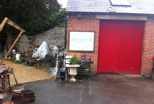
On the 12th of May we met as a group to visit the Stanmer. When we got to Stanmer, we first took photos of the park and signs of the Stanmer Park Restoration Plans. After which, we went to Stanmer House. We spoke to the Manager and asked some questions regarding environmental citizenship and some background information it. Unfortunately the Manager of Stanmer House didn’t know too much in regard to questions about preservation and public/local involvement. We then took photos of the House and set off to Stanmer Rural Museum. The Museum was closed when we arrived so we weren’t able to visit it but we took photos nonetheless (this was the only day we could all meet that week). The next place we visited was the Stanmer Village centre. In the Village centre there was the Donkey Wheel, the Church and one of the amenity centres for the local preservation society and took photos and read information regarding volunteering opportunities at the Donkey Wheel and also the Well.

28th April: Template and research for second outing

We gathered in the library as a group and discussed the template which we were going to use to critique Community 21. Here we talked about how we each felt about using the mapping system and what problems arose when we started to use it. The list of critiques came about as we thought of the map itself and its display, the information on the map originally and how it could be improved if the public were using it. This discussion gave us the base for our critique template. The group also talked about where we needed to visit for the second outing. The plan was made to visit Wild Park for the green spaces theme on heritage.

5th May: Presentation Day

On the Friday, we had an hour before our presentation to the rest of the class, to discuss with each other how far we had come in our research and what else we needed to add to Community21 after we presented. As a group we looked at what information each of us had added to the map and the content which would be included e.g. photos. Then went on to plan what topics we will talk about for the practice presentation and how we would present, whether all topics are discussed and who would be presenting.